


Story highlights
NEW: Hurricane Joaquin still has sustained winds of 130 mph, making it a Category 4 storm
NEW: "We have no ground, at all, for complacency," Pennsylvania's governor says
NEW: South Carolina joins Virginia, New Jersey in declaring states of emergency
The East Coast is on edge.
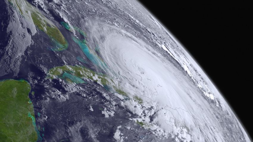
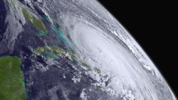
Hurricane Joaquin is the reason why. On Thursday, it lashed the Bahamas as a Category 4 storm with 130 mph winds. It’s what is expected to come next that has the United States worried: a stronger storm and a sharp turn north.
That’s why officials from South Carolina to New England have issued dire warnings to residents urging them to be ready. A lot could still happen with Joaquin; but one thing they don’t want to happen is another Superstorm Sandy – a strong, October hurricane that hit the Caribbean before pounding the Northeast.
“We don’t know for sure where the hurricane is going to go,” Pennsylvania Gov. Tom Wolf said. “But we have no ground, at all, for complacency.”
The good news: If current projections hold, Joaquin won’t be another Sandy.
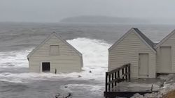
The not-so-good news: Hurricane projections are notoriously unpredictable. And regardless of whether Joaquin makes landfall, it probably will cause plenty of rain and more flooding along an already soaked East Coast.
Mark Fekete knows that all too well, which is why he isn’t taking any chances. After putting his hurricane shutters up, he’s leaving Sandbridge Beach, Virginia, to head inland.
“A lot of people don’t take it seriously until the last minute,” Fekete told CNN. “Then everybody’s got to get out of here.”
Joaquin hitting the Bahamas
For Thursday, Joaquin essentially parked over the Bahamas. The archipelago nation of more than 350,000 people will continue to suffer the consequences for many hours more, because the storm was crawling west-southwest at a mere 5 mph.

As of 8 p.m. ET, the U.S. National Hurricane Center reported that the storm was centered about 25 miles east-southeast of Clarence Town in the Bahamas and 75 miles south of San Salvador in the same island nation.
Forecasters say the hurricane will be near the northwestern Bahamas – including the country’s most populous city, Nassau – by Friday. That’s when the storm is expected to turn northward and began moving at a faster clip.
By that time, Joaquin could have 140 mph winds capable of causing catastrophic damage, the National Hurricane Center said.
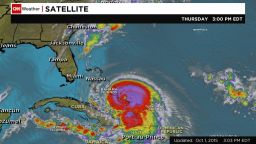
Ten to 20 inches of rain could fall over much of the central Bahamas through Friday, according to the hurricane center.
And rain and strong winds are not the only concerns. The hurricane center warned of “life-threatening surf and rip current conditions” as well as “a very dangerous and life-threatening storm surge (that) will raise water levels by as much as 5 to 10 feet above normal tide levels in the central Bahamas.”
Even as it crawled and mauled the Bahamas, the storm was already having an impact elsewhere – with 55 mph gusts on Thursday evening being felt as far away as Guantanamo Bay, Cuba. Hurricane-force winds were measured as far out as 50 miles from its eye.
“Joaquin is a large hurricane,” the Miami-based hurricane center pointed out.
Where it might make landfall in U.S.

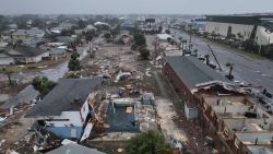
Joaquin’s forecast track shows it could be near North Carolina by Monday and possibly New Jersey a day later, hauntingly close to where Superstorm Sandy made landfall in 2012.
It was just three years ago this month that Sandy slammed the Northeast, devastating parts of New York, New Jersey and Connecticut.
But the projected path of the current storm system already has changed multiple times and could change again.
And should Joaquin make it back to the areas Sandy devastated before, it’s not expected to pack the same punch.
The “viral superstar” Sandy interpreter: Here’s what she’s doing now
When Sandy made landfall on October 29, 2012, it had hurricane-force winds. Joaquin has been projected to be a tropical storm once it gets that far north.
Heavy rains, flooding big worries on U.S. coast
The rain and waves? Now that’s a different story.
Hurricane Joaquin is lifting storm stocks
No matter where Joaquin goes, the storm is expected to bring significant rainfall to the East Coast, where some states already were dealing with flooding from separate systems this week.
“One way or the other, North Carolina, South Carolina, Virginia and on up will get between 5 and 10 inches of rain – even without a direct landfall,” CNN meteorologist Chad Myers said. “If we get a landfall, we get 15 inches of rain and winds of 80 mph.
“But without even a direct landfall, there will be significant flooding through the Carolinas, through Virginia, and all the way up the East Coast.”
Flood warnings were in effect Thursday evening from parts of Georgia and as far north as New Jersey. Many of them extended far inland, as far west as parts of West Virginia and Tennessee.
Even as far north as Waterbury, Vermont, Skip Flanders is keeping an eye out. He’s seen firsthand from 2011’s Hurricane Irene that the heavy rains from a huge tropical system like this can have devastating effects far from the coast.
“We had 28 inches of water in our house from Irene,” Flanders told CNN affiliate WCAX. “I certainly hope that something of that proportion doesn’t happen again.”
Such worries are compounded by the already drenched conditions in parts of the Northeast.
For example, flooding made some streets impassable in Portland, Maine, on Wednesday. Several cars were stalled on one street there after their drivers tried to make it through standing water, CNN affiliate WMTW reported.
How communities are getting ready
All these worries have spurred the governors of Virginia, New Jersey and South Carolina to declare states of emergency in advance of the storm. Such advisories were most salient in spots along the coast, where residents know all too well what havoc may await.
Along Virginia Beach’s Atlantic Avenue, a main thoroughfare about two blocks from the ocean, business owners appeared to be taking a wait-and-see approach. There were no boarded-up windows. Stores remained open, but there were only a few customers. It wasn’t clear if that was because of the weather or because it’s October in a beach town.
Asked what she was doing to prepare for Joaquin, Sharlotte Castillo of the beach shop Sunsations, about a block from the water, told CNN, “Pray, but we always pray, so nothing new. … We’re usually fine here – maybe a little rain, but we’re staying open.”
In eastern Pennsylvania, folks were taking the threat just as seriously. The Poconos took a beating during Sandy.
“What we’re expecting here is to be on alert for flash floods as well as power outages, and so we’re trying to get the word out to the community to think ahead, to have a plan,” Michele Baehr with the Red Cross told affiliate WNEP.
Dwyane Francis of Bushkill stocked up on canned goods.
“Preparation is the key. You have to be prepared for everything,” he said.
CNN’s Jason Hanna, Greg Botelho, Victor Blackwell, Tristan Smith, Eliott C. McLaughlin, Sean Morris, Monica Garrett, Dave Hennen and Kerry Chan-Laddaran contributed to this report.