Story highlights
Gulf system is now Tropical Storm Hermine
Hurricane warning in place for parts of Florida's Gulf Coast
In the Pacific, Tropical Storm Madeline and Hurricane Lester to swipe Hawaii
As people make outdoor plans to enjoy the last unofficial week of summer and the Labor Day holiday, several tropical storm systems are threatening the southeastern US and the Hawaiian Islands.
Several could make landfall – or at least brush the coastline – later this week, bringing heavy rains and possible flooding.
With the statistical peak of hurricane season approaching in early September, storms are spinning off the Carolinas and in the Gulf of Mexico.
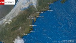
The system called Tropical Depression Nine in the Gulf of Mexico is now Tropical Storm Hermine, the National Hurricane Center announced Wednesday afternoon, after a NOAA Hurricane Hunter aircraft measured winds of 40 mph with the storm.
“Landfall is still expected overnight Thursday into Friday morning along the Big Bend to Panhandle region of Florida,” the hurricane center said.
Tropical Depression Eight – off the coast of North Carolina – may still become a tropical storm.
Here’s a breakdown of the storms and where they are heading.
Tropical Storm Hermine
This storm is the bigger threat to the Southeast this week. It’s expected to strengthen into a hurricane by the time it makes landfall, estimated to be shortly after midnight Friday morning.
Since landfall of this system is expected within 48 hours, the National Hurricane Center has issued a hurricane warning for portions of Florida’s Gulf Coast.
Any system that lingers in the Gulf in August or September will draw a long, watchful eye from forecasters and emergency planners, and Tropical Storm Hermine is no different.
Water temperatures in the Gulf are plenty warm enough to support hurricane development, and the Gulf Coast is full of vulnerable population centers from Tampa to Texas. The forecast calls for the weather system to drift toward the north and then move northeast Thursday as it gains strength.
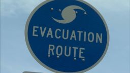
Gov. Rick Scott declared a state of emergency in Florida Wednesday morning.
“By declaring a state of emergency in advance of this storm, we are ensuring that state, regional and local agencies can work together to meet the needs of our communities,” he said.
Fortunately, an advancing trough over the central and southern US will kick the system to the east before it has a chance to strengthen much further, most likely leading to a landfall somewhere in the Florida Panhandle to the Big Bend area.
The longer the storm lingers in the Gulf before it makes the turn to the right, the more it could strengthen, and it may have a higher chance of landfall in the more populated Panhandle.
In addition to the wind and rough seas associated with tropical storms, heavy rainfall could also be a major threat from this system. Rainfall amounts of 5-10 inches are possible over the Florida peninsula through Friday morning and isolated totals could reach 20 inches, according the the National Hurricane Center.
“These types of rain totals, especially when they fall in just a few hours, could lead to flooding similar to what we saw in Louisiana just a few weeks ago,” CNN Meteorologist Chad Myers warned.
Tropical Depression Eight
The closest storm to US soil is Tropical Depression Eight, which was only 75 miles from Cape Hatteras in North Carolina as of Wednesday morning. Fortunately it has changed direction and is beginning to head back out into the open Atlantic. Some strengthening is expected as the storm accelerates northeast and it could become a tropical storm, which would earn the system a name.
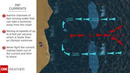
The major concern from this storm is the rip current threat that extends from North Carolina all the way to Florida and should not be underestimated by swimmers in that area.
Tropical Storm Madeline
The Central Pacific Hurricane Center in Honolulu has downgraded Madeline from a Category 1 hurricane to a tropical storm.
The weakened storm was passing just south of Hawaii’s Big Island on Wednesday.
Madeline had been a Category 4, before it weakened to a Category 1 and then into a tropical storm.
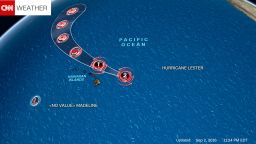
The center issued a tropical storm warning for the Big Island, as well as the islands of Maui, Molokai and Lanai. Given the elevated terrain of the islands and the rainfall – which could total 12 inches – these factors may cause dangerous mudslides and flash flooding.
Hurricane Lester
Hawaii residents cannot let their guard down after Madeline moves through, however, as Hurricane Lester is fast on its heels. Lester, a Category 3 hurricane, is expected to approach the Hawaiian islands this weekend. The forecast currently calls for Lester to miss the islands directly, pushing just to the north, but the entire island chain is still in the forecast “cone of uncertainty.” The Central Pacific Hurricane Center in Honolulu predicted some weakening in the next 48 hours.
Join the conversation
Hawaii frequently has storms approach the islands but rarely deals with hurricane landfalls directly. In fact, only two hurricanes have made landfall in Hawaii since 1950, and none have hit the Big Island. In 2014, Hurricane Iselle weakened to a tropical storm 12 hours before making landfall on the southern portion of the Big Island.
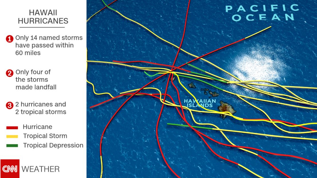
But recent studies have shown that hurricanes may become more frequent in Hawaii thanks to climate change, a pattern that’s certainly been seen over the past couple of years. El Niño also has played a role in the recent uptick of storm activity there.
CNN Meteorologists Judson Jones, Taylor Ward and Madison Park also contributed to this report.