


While there are plenty of awe-inspiring man-made destinations around the globe, nothing is as creative as nature.
From trees that resemble monsters, to colorful sinkholes, towering rock formations and waterfalls of molten lava, these are some of the most unusual and fascinating landscapes in the world.
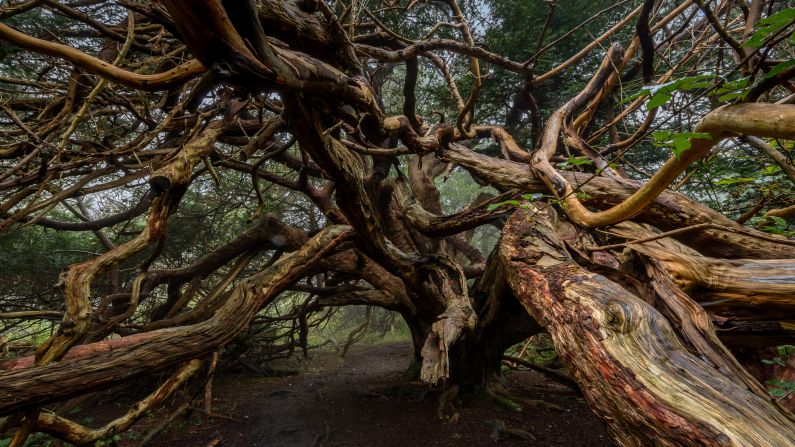
Kingley Vale, Sussex, United Kingdom
Gnarled and twisted over centuries, the yew trees of Kingley Vale could have been lifted straight from a Gothic fairy tale. Some are believed to be the oldest living things in Britain, dating back 2,000 years.
Yew tree groves were decimated in the 15th century, their wood used for longbows, making this stand of trees truly unique.
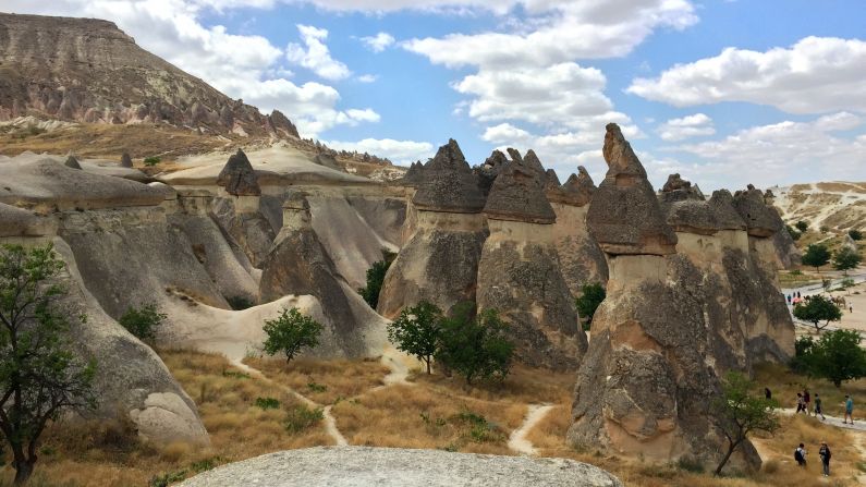
Fairy Chimneys, Turkey
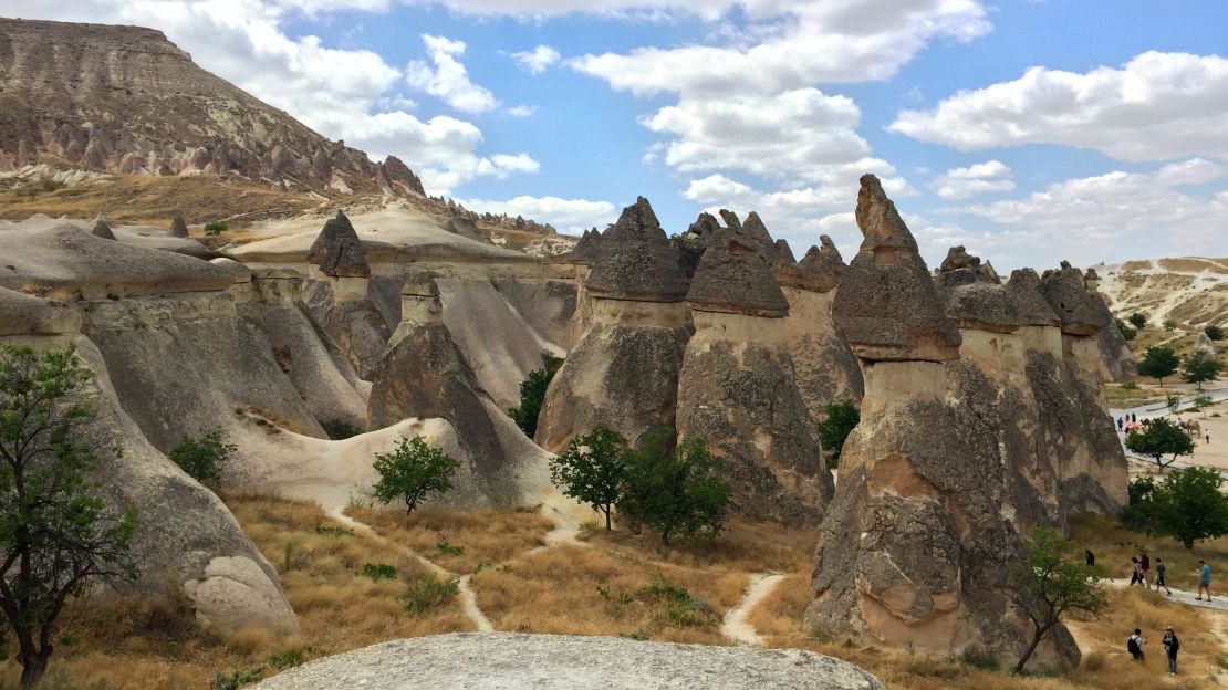
The Fairy Chimneys of Cappadocia in central Turkey are a geological marvel.
The hard basalt columns are the result of the surrounding, softer rock eroding over thousands of years, creating towers that appear otherworldly.
What makes them truly special, however, is the cave systems and cities dug out beneath them by persecuted early Christians and used whenever invaders passed along nearby trading routes.
Giant’s Causeway, Northern Ireland
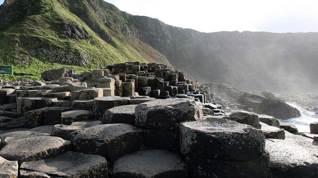
On the wild north Atlantic Coast of Northern Ireland, Giant’s Causeway is the stuff of actual legend.
The story goest that it was created by the giant Finn McCool to face off against his Scottish rival Benandonner, and destroyed by the latter as he retreated home.
While the reality is a touch less fantastical, it’s no no less amazing. The pillars are the result of lava cooling and contracting over millions of years.
Sister formations can be found at Fingal’s Cave in Staffa, Scotland, all part of the same lava flow.
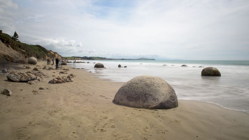
Moeraki Boulders, New Zealand

The large, spherical Moeraki Boulders could easily be mistaken for man-made creations that have washed up on Koekohe Beach on the North Otago coast.
Local Maori legend claims they are the remnants of fishing baskets and fruits that came ashore when their Araiteuru Canoe was wrecked bringing their ancestors to New Zealand’s South Island.
In truth, these two-meter-high stones were created by mudstone hardening over five million years, before appearing as surrounding rocks were eroded.
Great Blue Hole, Belize
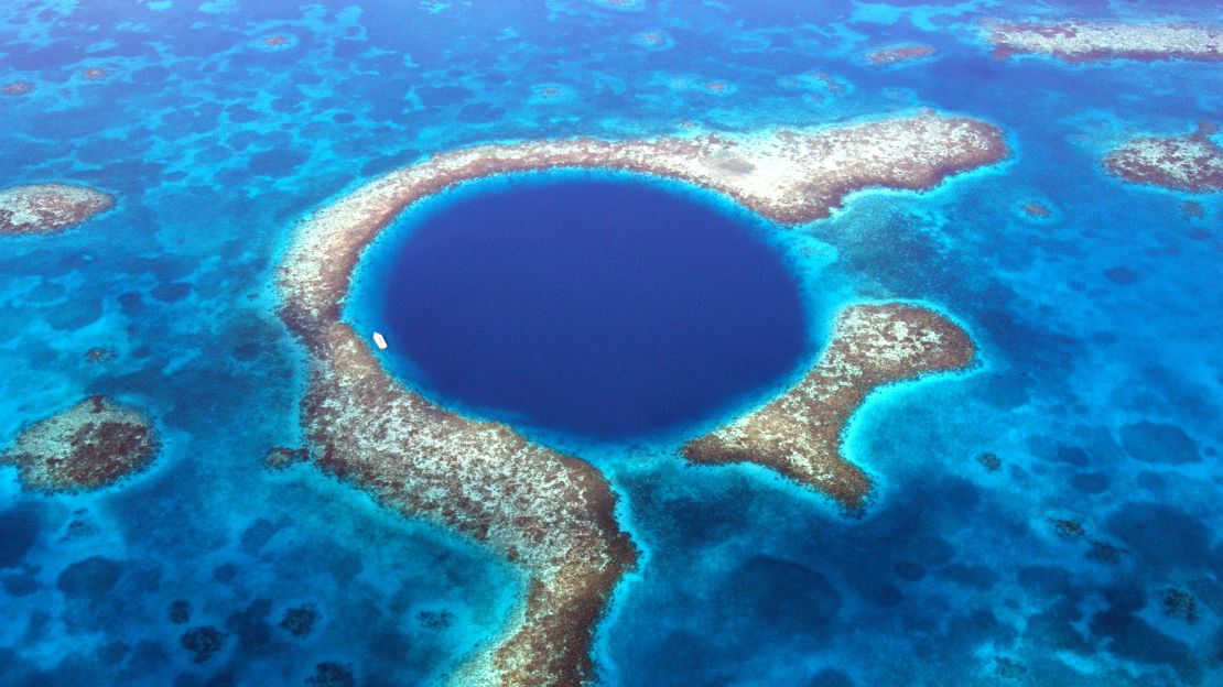
At 300 meters wide and around 125 meters deep, the Great Blue Hole is the biggest sinkhole in the world.
Part of the Belize Barrier Reef System, the hole was formed as sea levels rose thousands of years ago, flooding its deep caves.
Made famous by renowned marine explorer Jacques Cousteau, recent submarine trips have created new 3D sonar maps, showing never-before-seen mineral formations close to the hole’s bottom.
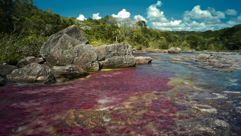
Cano Cristales, Colombia
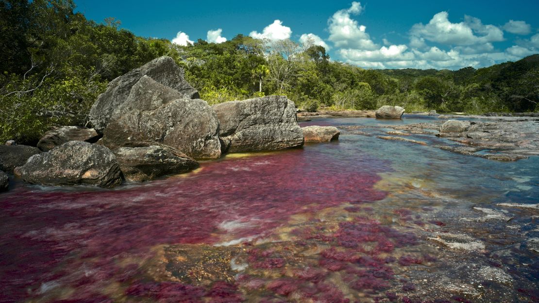
In the brief period between Colombia’s wet and dry seasons, the waters of Cano Cristales become a riot of red, yellow and green.
This vibrant occurrence is due to Macarenia clavigera, a plant found on the riverbed.
It only turns red between September and November, which is after the fast-flowing water of the wet season abates, but before the dry season evaporates too much water for it to keep its colorful look.
Swimmers are allowed in certain sections, but can’t wear sunscreen in order to protect the fragile ecosystem.
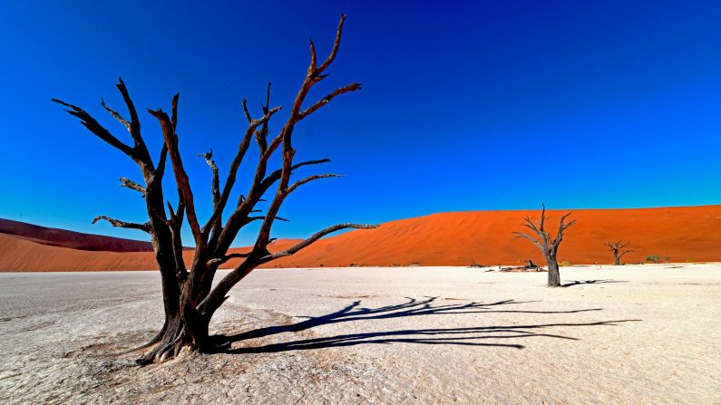
Dead Vlei, Namibia

Dead Vlei, literally dead marsh, sits among the tallest sand dunes in the world, with some as high as 400 meters.
Once abundant, the now almost barren area is home to a vast stand of dead Camel Thorn trees, dried out because of an intense change in climate 900 years ago.
The dry weather means they cannot decompose, creating a truly eerie landscape.
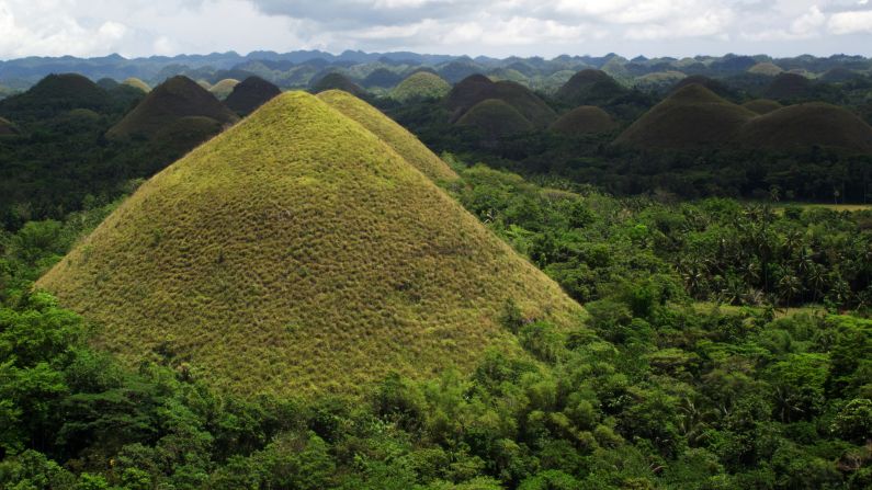
Chocolate Hills, Philippines

The rolling Chocolate Hills of Bohol in the Philippines could easily be mistaken for a child’s landscape drawing.
But these 1,268 hills are very much a natural phenomenon: conical limestone peaks formed through the actions of water and erosion over thousands of years.
Their name derives from their grass covering, which turns brown during the dry season, with December to March the best time to visit. Legend has it the hills are the dried tears of a heartbroken giant. While the truth is more prosaic, the views are still spectacular.
Kilauea, Hawaii
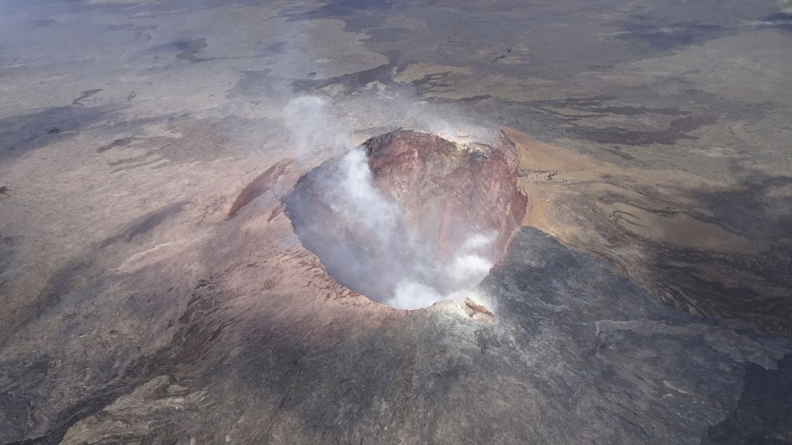
The most active volcano on the island of Hawaii, Kilauea is in a state of near constant eruption, molten lava oozing down roads and destroying homes and holiday resorts.
Its 2018 eruption saw vents explode, rivers of lava flowing into the Pacific Ocean and sending toxic fumes into the air.
Believed to be between 210,000 and 280,000 years old , it surfaced above sea level on the southern eastern shore of the island around 100,000 years ago.
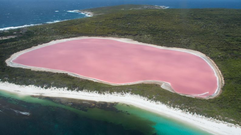
Lake Hillier, Australia

Just a few meters from the sand and surf on the coast of Middle Island, in Australia’s Recherche Archipelago, Lake Hillier’s brash pink water is in stark contrast to the bright blue of the nearby ocean.
Its color is thought to be derived from algae called Dunaliella salina, which produces a pigment that turns the salty water a seemingly unnatural hue.
Halophilic bacteria in the salt crusts that surround its banks are also considered to be behind the phenomenon.
Devils Tower, Wyoming
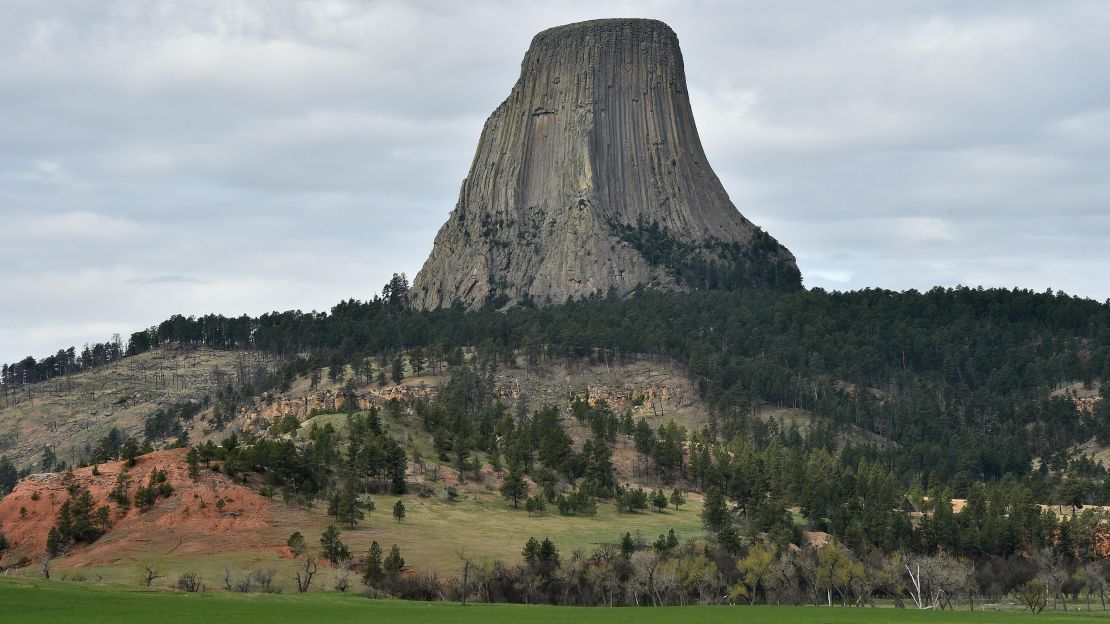
Protruding high from the prairie into the Wyoming sky, Devils Tower (the apostrophe omitted ever since it was given the name in the 19th century) is sacred to several Native American tribes.
A butte rising some 385 meters above the Belle Fourche River, it was formed by surrounding sedimentary rocks eroding, leaving the igneous rocks to stand sentinel over the area.
The Lakota believe Devils Tower rose to protect two girls from a chasing bear, the marks surrounding the tower left by its claws.
Sci-fi aficionados will recognize it as the alien rendezvous point from Steven Spielberg’s 1977 movie “Close Encounters of the Third Kind.”
Dallol, Ethiopia
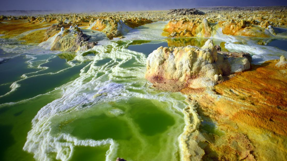
With temperatures averaging a blistering 94 degrees Fahrenheit, Dallol is one of the most inhospitable places on Earth.
Close to the border with Eritrea, its ethereal, Martian landscape sits within the Danakil Depression.
Besides its ungodly heat, Dallol is best known for its colorful hydrothermal fields, with aquamarine green pools and yellow rocks appearing like a surrealist painting against the florid red rock formations.
The bright colors are due to inorganic iron oxidation.
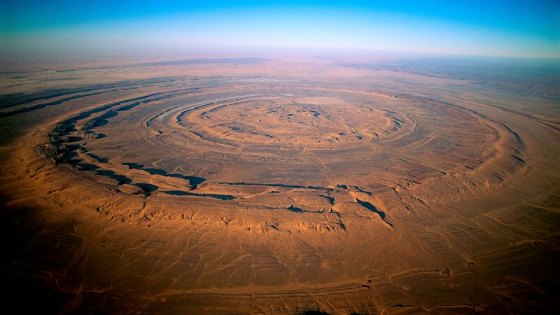
The Eye of the Sahara, Mauritania

Known also as the Richat Structure, the Eye of the Sahara looks pretty much like any other part of this continent-straddling desert from the ground. But from up in space, this 40-kilometer wide geological marvel is something else.
Believed to be an eroded dome, rather than an impact crater, it resembles a fossilized ammonite when seen from Earth’s orbit.
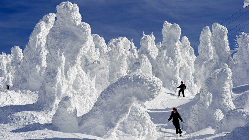
Snow Monsters, Mount Zao, Japan

High in Japan’s northern Tohoku region, Mount Zao is home to this vast swathe of icy sculptures. As winter comes on hard and harsh, Siberian winds blow across the Zao range and snow falls and freezes on the mountain’s trees.
The trees then freeze into interesting forms, resembling creatures straight out of a manga comic.
Regular light shows help add to their allure after dark, although a cable car across their peaks in daylight is just as fascinating.
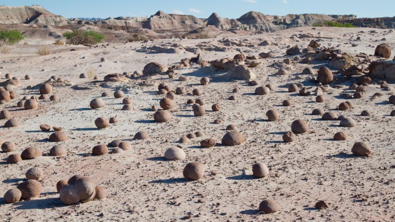
Valley of the Moon, Argentina

The clue’s in the name of this vast area in northern Argentina: lunar landscapes of wind blasted rock, where the night skies are illuminated by billions of stars and the moon glows.
Also known as the Ischigualasto Provincial Park, its most famous sights include The Sphinx, which resembles its Ancient Egyptian namesake.
There’s also The Mushroom, a tower that blooms out into a wide formation at its summit and the Bowling Field, where spherical rocks dot the landscape.
Vermilion Cliffs, Arizona
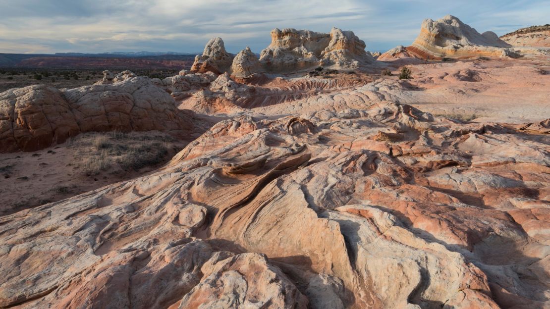
Just south of the Utah state line, Vermilion Cliffs is one of the most visually arresting places in the United States.
The area’s swirling sandstone canyons and arches are ripe for exploration, with few visitors likely to be encountered.
The vast cliffs themselves, which run for 48 kilometers and range between 2,000 and 3,000 feet, can be seen in all their glory from Highway 89A.
Haukadalur geothermal field, Iceland
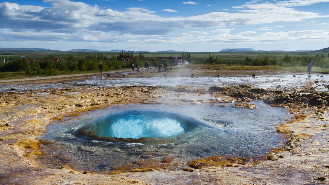
Iceland’s geothermic wonders make it a paradise for seekers of weird and wonderful landscapes.
Most famous for its Geysir and Strokkur erupting hot springs, this vast area, 60 kilometers east of Reykjavik, is worth taking time to explore, especially as there’s a handy campsite close by.
Mentions of the bubbling, geothermal fields here date back to 1294, when they were activated by an earthquake.
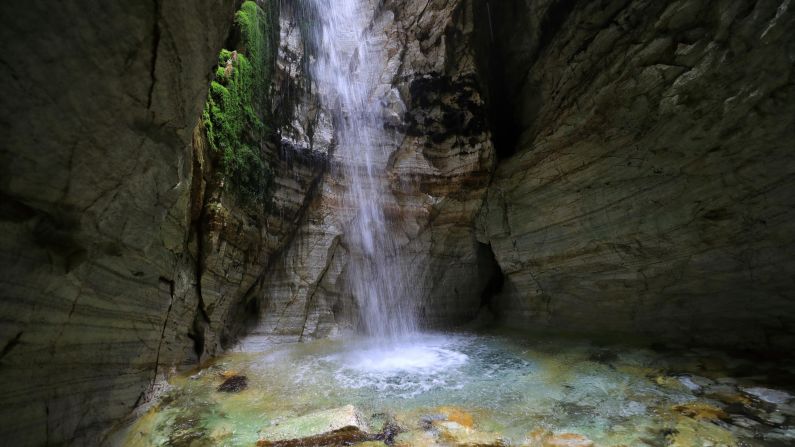
Trollkirka Caves, Norway

Norway’s Trollkirka Caves, literally Troll Church Caves, aren’t places of worship in the traditional sense. Instead, they’re marble and limestone marvels that intrepid visitors can enter after a strenuous hike.
The key attraction here is the 70-meter main cave, which boasts a waterfall. Smaller grottoes play home to sparkling pools, the water bright and clear against the white rock, which appears to have folded in on itself over million years.
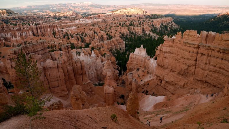
Bryce Canyon, Utah

Far less popular than nearby Grand Canyon National Park, Bryce Canyon is arguably every bit as extraordinary.
It appears red, white and yellow against the bright blue sky thanks to the “hoodoos” that stand to attention for miles in every direction.
These columns, made of soft rock at the bottom and harder rock at the top, are the result of millennia of weathering and erosion. They sit within a series of huge natural amphitheaters that look spectacular at sunset.
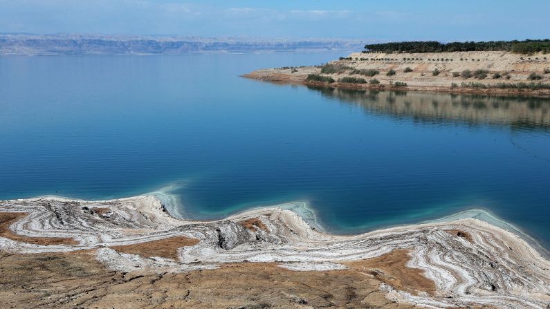
Dead Sea, Israe/Jordanl

The lowest point on Earth, the Dead Sea is more than nine times saltier than the sea.
Thought to be part of a rift zone that extends north into Turkey, it’s believed to have once been part of a lagoon connected to the Mediterranean.
Salt deposits on its bottom ensure that bathers remain buoyant, while the water’s rejuvenating properties have made it a go to for health tourists for centuries.
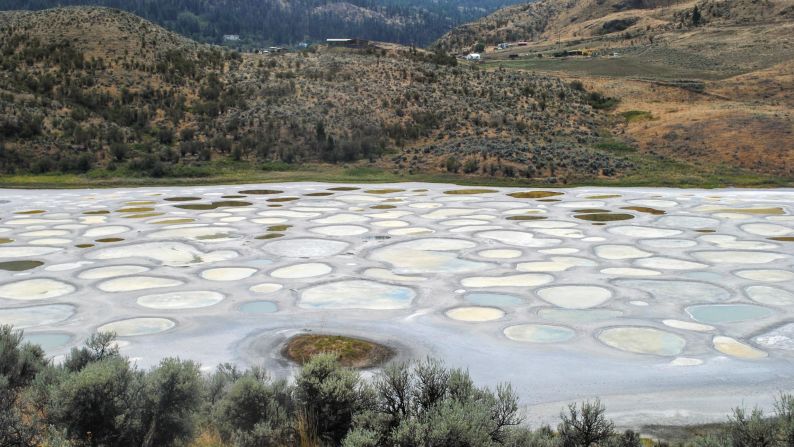
Spotted Lake, Canada
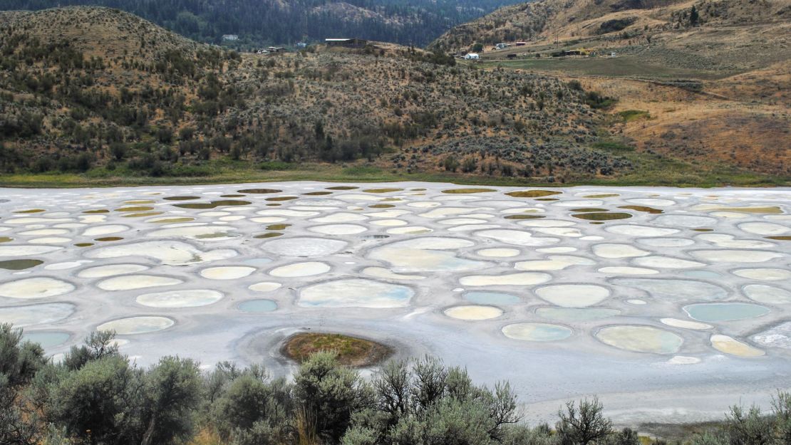
In the heart of British Columbia, Spotted Lake looks like your average body of freshwater during winter. But as temperatures rise and the water evaporates, it becomes something wholly different.
Huge blue, yellow and green spots appear, the result of deposits of magnesium sulphates, sodium sulphates and calcium.
The Okanagan First Nations people believed the spots to have different curative properties, they have owned the surrounding land since 2001.
Blood Falls, Antarctica
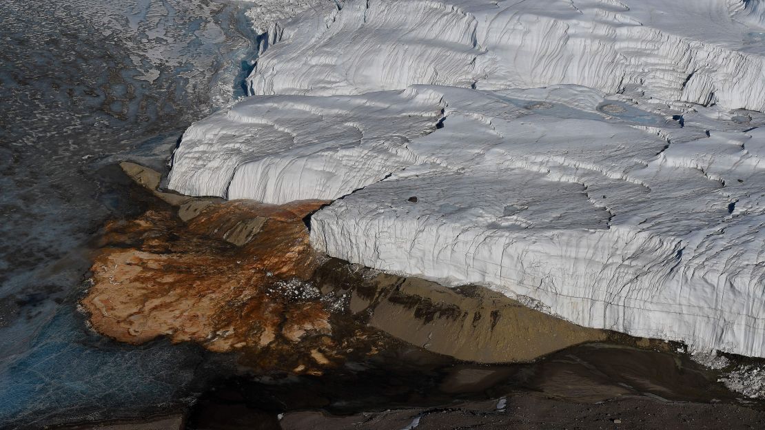
Flowing from Antarctica’s Taylor Glacier, Blood Falls’ ghoulish color is rooted in deep time.
In 2017, scientists discovered the scarlet hue is due to oxidized iron in brine saltwater, which has taken one and a half million years to get to the falls, rather than discoloration by algae as previously thought.
When the water makes contact with oxygen, it oxidizes and turns red.
A brine lake underneath the glacier, exposed to iron rich rocks, is believed to be the water’s source.
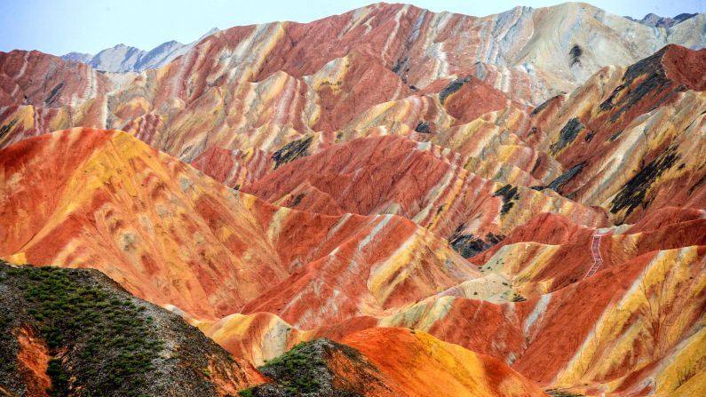
Zhangye Danxia Landform Geological Park, China
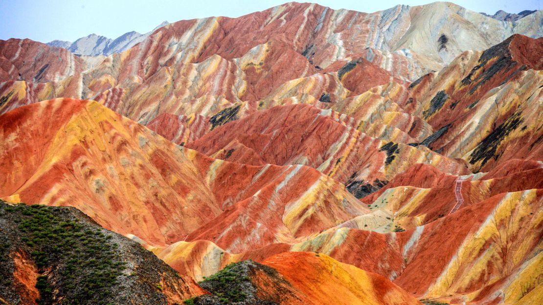
The “Rainbow Mountains” of the Zhangye Danxia Landform Geological Park are striking examples of what millions of years geological activity can do to a landscape.
Made up of layers of sandstone, mudstone and multicolored sedimentary rocks laid down over millions of years, their sharp tilt is due to the movement of the tectonic plates which also formed the Himalaya.
River erosion helped form the deep gorges and high peaks, with purple, green, yellow and red strata creating a brash and bright vista.
Darvaza Gas Crater, Turkmenistan
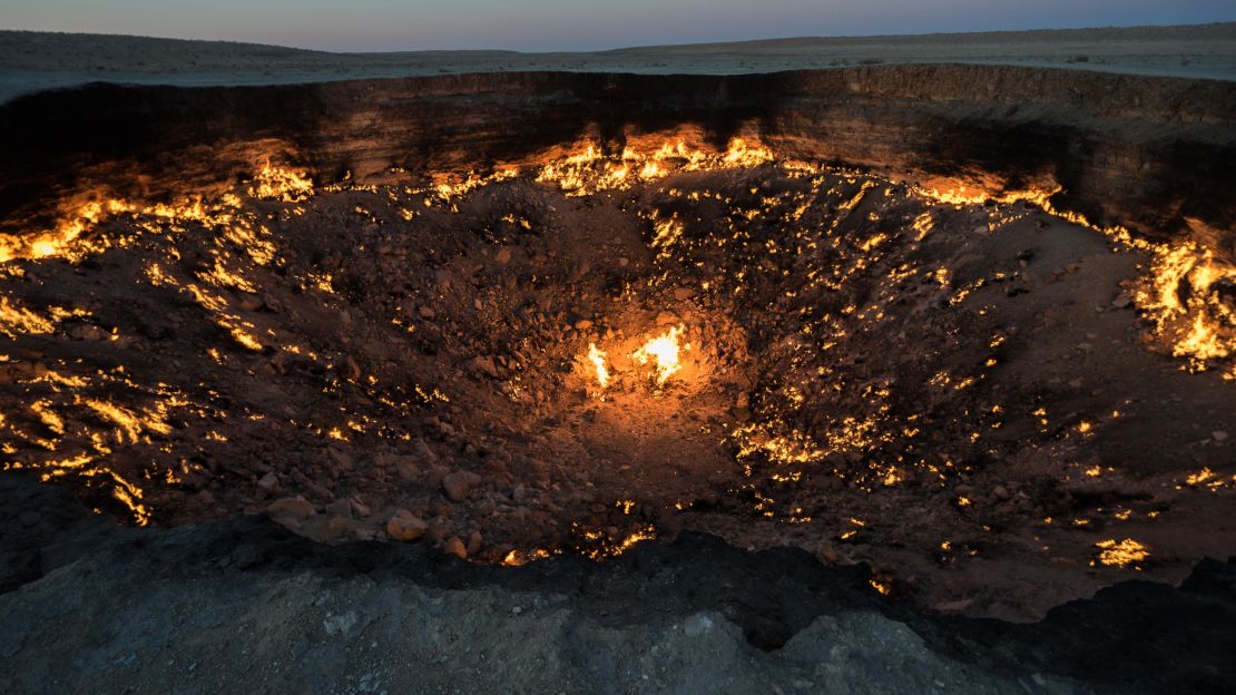
Known by locals as the Door to Hell, the Darvaza Gas Crater is a natural phenomenon brought about by man less than half a century ago.
While searching for oil, Soviet engineers discovered a natural gas pocket that soon collapsed, consuming their equipment.
Panicked by the release of methane potentially killing wildlife in the surrounding Karakum Desert, scientists set the gas crater alight in the hope it would soon burn out.
Today, it still burns brightly, to a depth of 30 meters, and has become a major draw for tourists heading to this little-visited country in Central Asia.
Editor’s note: This story was updated to clarify the location shown in the Dead Sea photograph.
Joe Minihane is a freelance travel writer and editor. His latest book is “Floating: A Life Regained,” a memoir about wild swimming and anxiety.