

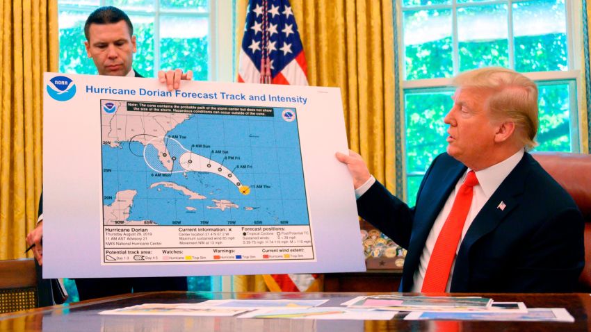
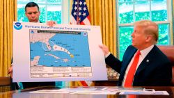


President Donald Trump showed a map of Hurricane Dorian’s trajectory in the Oval Office on Wednesday afternoon that appeared to include an addition showing the storm potentially affecting a large section of Alabama.
Trump claimed the map was the original forecast. But a similar image released by the White House last week did not include any impact on Alabama in its forecast.
“That was the original chart, and you see it was going to hit not only Florida but Georgia,” Trump claimed Wednesday during a briefing, while showing a National Oceanic and Atmospheric Administration map with a black line encircling a portion of Alabama.
“It took a right turn. And, ultimately, hopefully we’re going to be lucky. It depends on what happens with South Carolina and North Carolina,” he added.
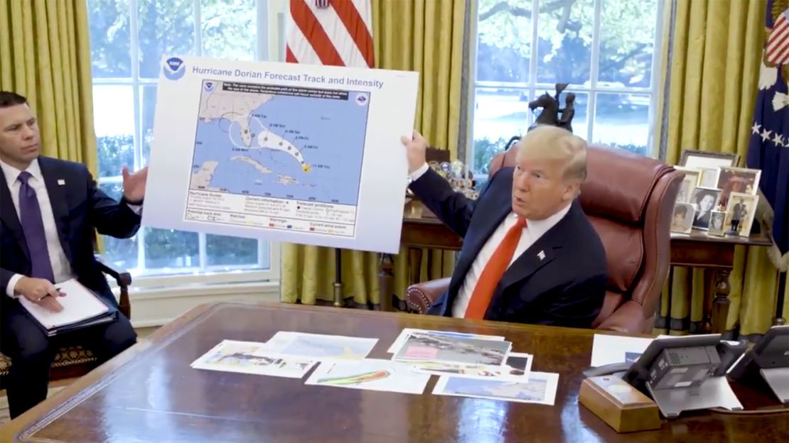
A White House official told CNN there had been a discussion in the Oval Office before the briefing about what the early models showed and that Dorian could have been worse than initial projections. One of the officials in the room agreed and used a black marker, unprompted, to make the point by extending a line all the way into the southeast region of Alabama, according to the official, who described the situation as “innocuous.”
The official said the graphic wasn’t part of the initial presentation, and that it was behind Trump but the President moved it during the presentation to show how bad Dorian could have been.
A source familiar with the briefing would not deny that Trump had drawn the black line on the map. “I’m not going to get into that,” the source said, but confirmed the line had been added during the storm briefing Wednesday, before the press entered the Oval Office.
NOAA referred questions to the White House, whose press office did not immediately respond to queries about the map.
A NOAA spokeswoman also declined to answer whether Alabama had ever been in the cone of impact, saying she would need to follow up because she didn’t have the information in front of her.
Over the course of the storm’s development, Trump has erroneously claimed multiple times that Alabama had been in the storm’s path. The claim got pushback from weather experts, including the Birmingham, Alabama, branch of the National Weather Service.
“Alabama will NOT see any impacts from #Dorian. We repeat, no impacts from Hurricane #Dorian will be felt across Alabama. The system will remain too far east,” the branch tweeted.
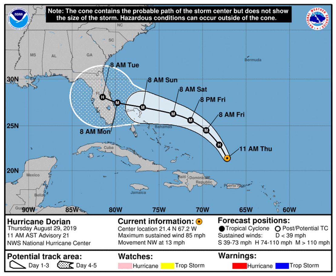
An early archived version of a NOAA map from Thursday, August 29, showed the hurricane veering left toward Florida, but it did not appear to have a black line to show Alabama would be affected.
CNN Weather meteorologists say one forecast on Friday afternoon showed one-tenth of one county in extreme southeast Alabama was included in one model. But that map bears little resemblance to the one Trump showed on Wednesday. And the official track from the National Hurricane Center never showed Dorian’s track entering the Gulf of Mexico, as Trump also claimed.
“I know that Alabama was in the original forecast,” Trump said later Wednesday when asked about the image he showed, adding that there were other maps showing Alabama being “hit very hard.”
Asked whether the black line over Alabama was made with a permanent marker, Trump said, “I don’t know. I don’t know.”
A source familiar with the matter says the Department of Homeland Security, which oversees the Federal Emergency Management Agency, did not provide the altered map Trump showed in the Oval Office.
“The map was not brought by DHS for this briefing,” the source said.
Despite the White House’s assertion that Trump was being briefed hourly on the hurricane, the President appeared to stand by his claim Wednesday night by citing a seven-day-old hurricane projection map from the South Florida Water Management District. The map – a spaghetti model projection – shows multiple Southeastern US states in Dorian’s path, including Alabama.
“This was the originally projected path of the Hurricane in its early stages. As you can see, almost all models predicted it to go through Florida also hitting Georgia and Alabama,” Trump tweeted.
But spaghetti plots like the one Trump tweeted are not forecasts. Instead, they show raw output from a computer model, with their data taken into account by the National Hurricane Center meteorologists who issue the official center forecast.
Additionally, spaghetti model projections from Sunday – when Trump first tweeted about Alabama potentially being in Dorian’s path – didn’t include any potential track for the storm to hit Alabama.
Text at the bottom of the map Trump tweeted states, “If anything on this graphic causes confusion, ignore the entire product.” It also says National Hurricane Center statements “supersede this product.”
CORRECTION: This story has been updated to accurately describe the location of the county in southeast Alabama that was included in one model forecasting the path of Hurricane Dorian.
CNN’s Jim Acosta, Gregory Wallace, Jeremy Diamond and Betsy Klein contributed to this report.