Severe thunderstorms return to the Plains on Tuesday as a dramatic temperature swing brings potentially record-breaking, summerlike heat to the eastern United States this week.
The weather pattern will evolve as the jet stream dips across the West, bringing cooler temperatures from the North, while a ridge builds across the East, which signifies warmer temperatures.
In between this temperature battleground, the risk for severe storms builds Tuesday and Wednesday across the Central US.
“Wild temperature swings like we have coming up this week really can only happen in spring and fall. They set up classic severe weather days and the potential for widespread agricultural freeze damage,” said CNN meteorologist Chad Myers.
Severe weather ramps up
A storm system will develop over the central Plains and this will fuel the risk for severe storms, especially on Tuesday.
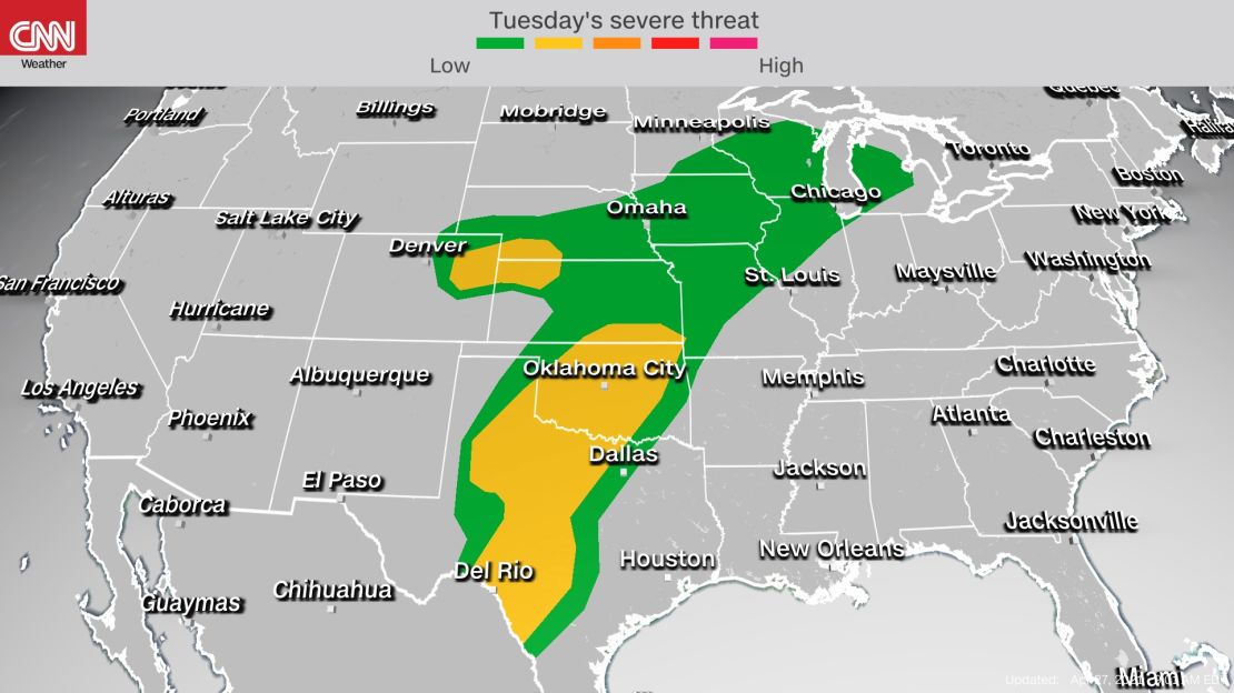
There is a level 2 out of 5, slight risk for severe storms for parts of Kansas, Oklahoma and Texas, including Oklahoma City, Tulsa, Wichita, Lubbock and Abilene.

There could be an “uptick in tornado potential during the evening across this area, and locally stronger wind gusts will also be possible. However, large hail will remain the primary severe risk through the period,” according to the Storm Prediction Center.
The main timing for the storms will be Tuesday afternoon into night. Showers and storms could already bring poor weather to parts of the southern Plains during the day, but the severe threat won’t ramp up until the end of the day when storms fire up across western Texas and then track east.
Strong storms remain likely overnight Tuesday, so it is important to have weather alerts set on your phone in case bad weather becomes imminent in your town.
A few isolated severe storms will also be possible across parts of the upper Midwest and central Plains.
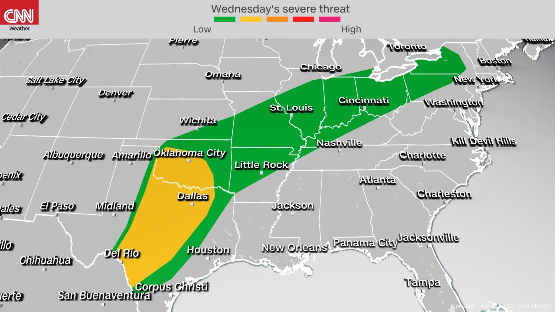
The risk for scattered severe storms will persist into Wednesday. The Storm Prediction Center has issued a level 2 out of 5 risk for severe weather, spanning an area from the Rio Grande in Texas through central Oklahoma. That includes San Antonio, Dallas, Austin and Oklahoma City.
Tornadoes, damaging winds and large hail will remain possible during some of Wednesday’s storms.
Isolated severe thunderstorms are also expected from the central Plains through the interior Northeast on Wednesday.
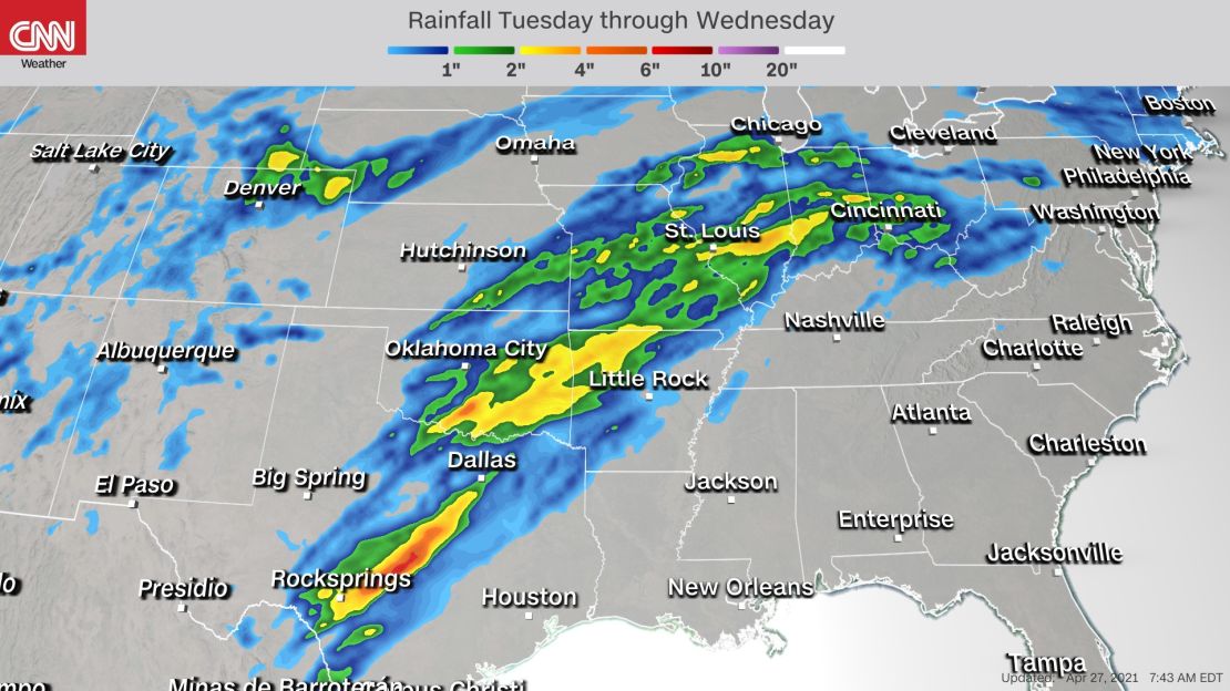
Some locations could deal with multiple rounds of heavy thunderstorms Tuesday into Wednesday across the Central US, so along with the wind and hail threats, there will also be a flash flood threat.
A widespread 1 to 3 inches of rainfall is forecast from central Texas through the lower Midwest, with localized rainfall amounts of up to 5 inches possible.
Warm air moves toward East Coast
As these storms gradually track east, so will the warmer air.
The heat will spread toward the East Coast on Tuesday, with above-average temperatures reaching the mid-Atlantic and Southeast coasts.
High temperatures could rise by more than 15 degrees in some cities. In Washington, DC, the forecast high on Monday is 67 degrees but it will surge up to 83 on Tuesday.
And that warming trend will increase for Wednesday near the East Coast. High temperatures could approach 90 degrees as far north as the mid-Atlantic.
The Northeast will feel the warm temperatures Wednesday as well. In New York City, for example, it will rise from the low 60s on Monday to the mid 80s by Wednesday, a temperature increase of more than 20 degrees.
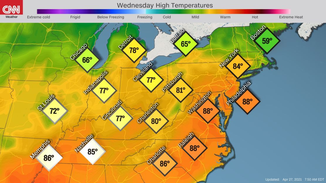
Record high temperatures are currently not expected Wednesday, but they could get within about 5 degrees of meeting records in New York, Washington, Philadelphia and Richmond, Virginia.
Low temperatures will likely be broken, however, for being the warmest on record.
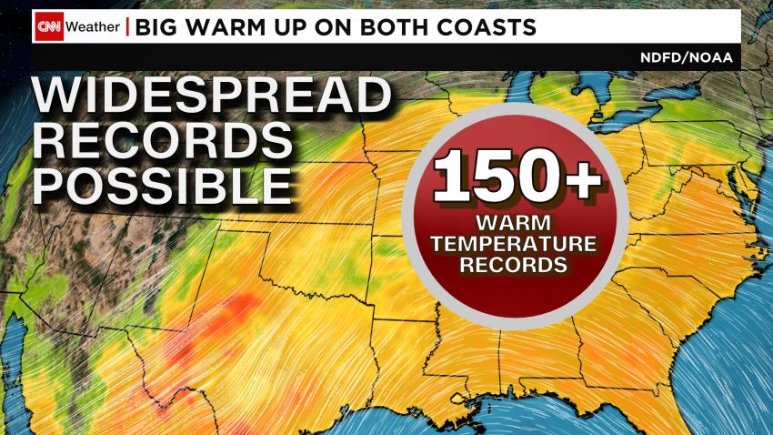
Between Tuesday and Friday, over 150 daily record high and warm minimum temperatures could be broken, shifting from the Midwest midweek to the Mid-Atlantic on Thursday and Friday. Widespread low temperatures in the 60s are forecast, with highs in the mid-80s.
Widespread highs of 10 to 20 degrees above average are forecast for the Midwest and Northeast Wednesday.
What goes up must come down, however. By Thursday, temperatures will be on the decline across the Midwest and Northeast but still 5 to 15 degrees above average.
The Southeast will be 5 to 10 degrees above average, with high temperatures near 90 away from the coast, from central North Carolina through southern Georgia and into Florida.
Cooler temperatures will dominate most of the East by this weekend while a new round of warmth begins to take charge across the central US. Highs will drop to 5 to 15 degrees below normal in the eastern US.