
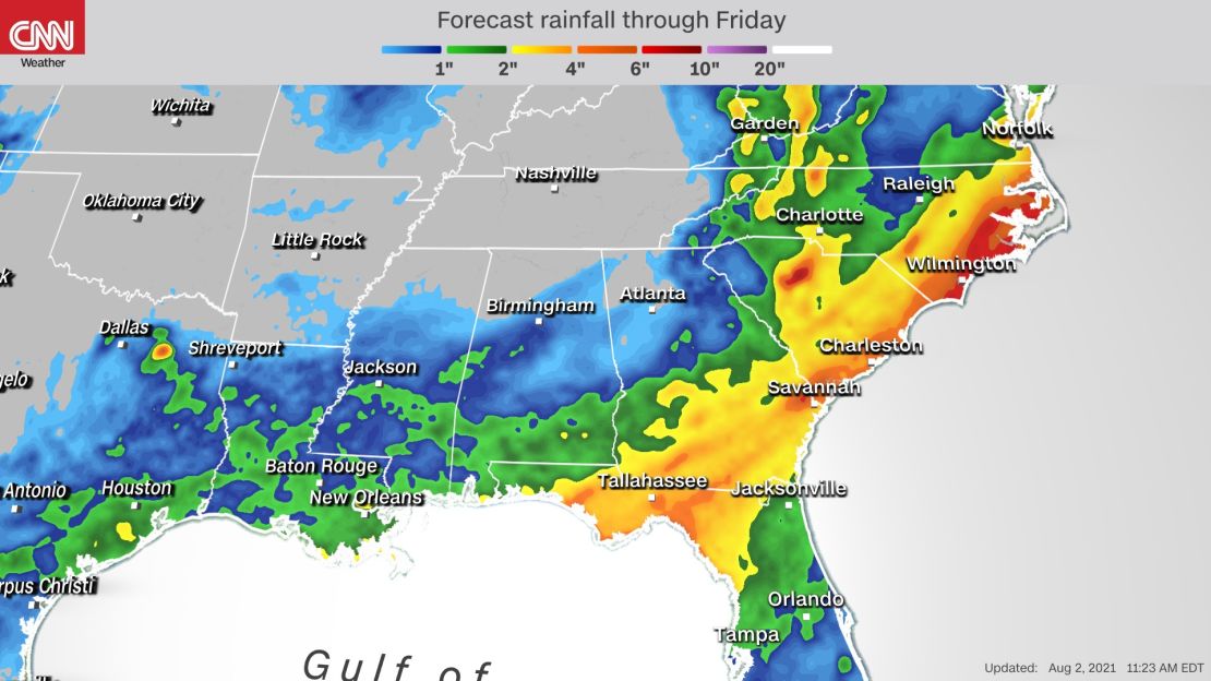
Showers and storms will build throughout the week along the Gulf and East coasts as a cold front stalls in the Southeast.
Following a week of triple-digit heat index values, a cold front sagging into the region will provide cooling rainfall to the coastal Southeast but might put a damper on beach days for some.
“The recent oppressive heat across the Deep South will be cooled by more numerous showers and thunderstorms today as a cold front slowly edges in from the north. The front is forecast to reach the Gulf Coast on Tuesday and then becomes nearly stationary,” the Weather Prediction Center said.
With rain stationed over the same areas the entire week, heavy downpours will threaten flash floods, especially in urban and poor drainage areas.
Wet start for the Gulf
Scattered showers and thunderstorms are expected to develop throughout the afternoon and evening Monday across the northern Gulf Coast, with some locally heavier amounts of rainfall totaling three to five inches.
The WPC has a slight risk for excessive rainfall extending from Louisiana through the Carolinas, where the highest rain totals and strongest storms are expected. The heaviest rainfall is concentrated from Louisiana through South Carolina.
“With such a richly and deeply moist air mass, torrential rainfall rates and runoff issues will become the main concern,” the National Weather Service in Tallahassee said.
Localized flooding is possible with the heaviest rainfall, but rivers could also reach the flood stage in the region over the week due to up to seven inches of rain in some places by Friday, according to NWS Tallahassee.
The heaviest period of rain for the Louisiana coast and Florida Panhandle is at the start of the week, slowly diminishing as the week progresses. Louisiana will see conditions clear up into midweek, while the Apalachee Bay, south of Tallahassee, remains a bull’s-eye for heavy rainfall in Florida a bit longer.
The nature of the showers will become more sporadic toward midweek for the Gulf Coast, bringing back periods of sunshine and more moderate temperatures for beachgoers.
Heavy rain in the Carolinas
As the west end of the front sags south off the Gulf Coast, the regions of the heaviest rainfall are expected to shift eastward into the Carolinas on Tuesday.
North Carolina is expected to see the highest rain totals as some intense downpours could bring up to 5 inches of rain in localized areas along the coast.
A slight risk for excessive rainfall is outlined over coastal North and South Carolina on Tuesday and Wednesday. Rich moisture from the Atlantic coupled with the approaching front could cause heavy downpours and flooding rainfall.
“Even though a stronger thunderstorm cannot be ruled out, flooding will be the main hazard, especially in areas that continuously see heavier bouts of rain. Generally, Southeast Georgia will receive between 2-4 inches with Southeast South Carolina receiving 4-6 inches over the course of three days,” said NWS Charleston, South Carolina.
The Carolinas will see most of their moisture Tuesday through Thursday this week as the area of highest precipitation moves to the East along the front. North Carolina might see six to eight inches of rain within the three days alone.
The region has already seen above-average rainfall over the past month. Wilmington, North Carolina, recorded 8.85 inches of rainfall in July, nearly two inches above average.
“Given that much of the area has received around-to-well-above normal precipitation over the past couple of weeks, there will be a significant flash flooding threat that will require close monitoring midweek,” said NWS Newport/Morehead in North Carolina.
Areas closest to the coast in North Carolina could see up to 10 inches of rainfall by the time Friday arrives, recording more rain than all of July in just the first week of August for some areas.
The front causing the surge in moisture retreats and pulls northward by the end of the week, easing up on the rainfall for the coasts in most areas by the start of the weekend.