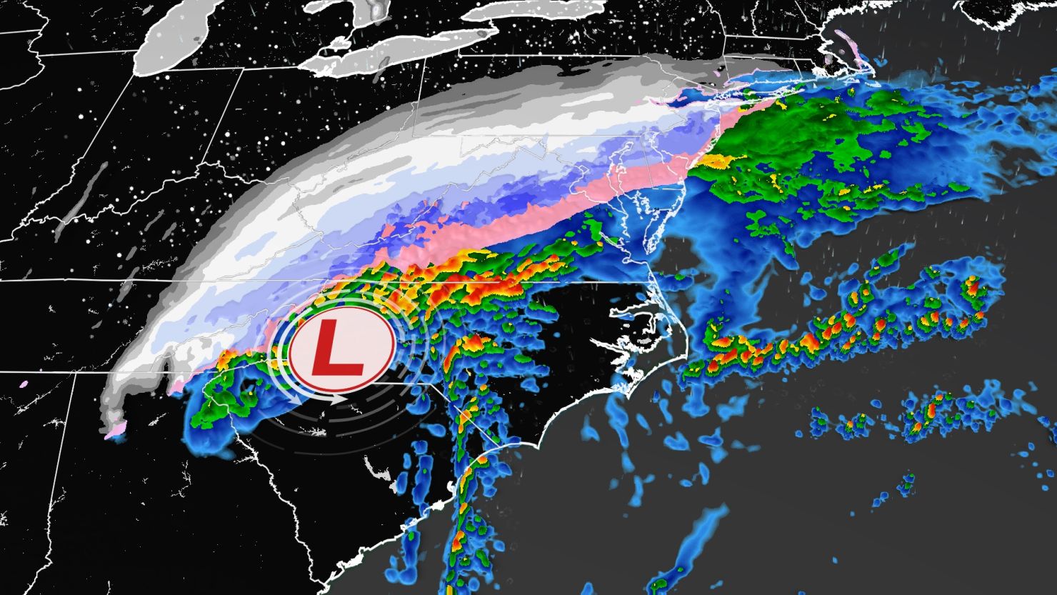
The first snow of the winter season is forecast for some areas across the South and Mid-Atlantic on Sunday and Monday.
Winter weather alerts are in place from eastern Texas through Tennessee and into the Mid-Atlantic. Across portions of Texas and Louisiana, a mix of light freezing rain, sleet and snow could lead to a trace of ice accumulations and a light glaze – mainly on elevated surfaces – through Sunday morning.
Portions of northern Alabama, northern Georgia, northern South Carolina and eastern Tennessee are now under a winter storm warning, according to the National Weather Service (NWS). These areas may see around 2 to 5 inches of snow, especially in higher elevations.
There are now at least 14 million people under a winter storm warning.
Across northern Mississippi, most areas could also see up to an inch of snow through Monday morning. Some isolated locations, especially in higher elevations, could see upwards of 2 inches fall.
Higher snowfall totals of 4 to 8 inches are possible across the southern Appalachians in areas covered by winter storm warnings. Areas of the Mid-Atlantic, including Washington, DC, could see snowfall accumulations of 3 to 6 inches through Monday.
In addition, winter weather alerts are in place across interior portions of New England, where 3 to 5 inches of fresh snow are expected Sunday.
Meanwhile, severe storms and flooding rains are forecast for a stretch of the Southeast.
A level 2 out of 5 risk for severe storms is in place across the Southeast on Sunday, including for Savannah, Georgia; Tallahassee, Florida; and Columbia and Charleston, South Carolina. Thunderstorms with damaging wind gusts, a few tornadoes and isolated large hail are all possible through Sunday night.
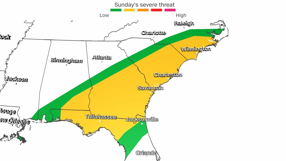
Heavy rain is also possible over much of the Southeast on Sunday as the storm system moves east, increasing the chances of flash flooding. A level 2 out of 4 risk of excessive rainfall is in effect for a small portion of southern South Carolina and eastern Georgia.
Arctic air and wind chill alerts
East Coast temperatures will be above average Sunday before giving way to more seasonal air behind the passing storm system.
New Jersey Gov. Phil Murphy declared a state of emergency for five counties that are currently under a winter storm warning.
Beginning at 9 p.m., Atlantic, Burlington, Cape May, Cumberland and Ocean Counties entered a state of emergency. State offices will have a delayed Monday opening at 10 a.m., Murphy said.
Up to 2 inches of snow is possible and coastal flooding is anticipated in southern counties.
Meanwhile, below normal temperatures are expected over much of the central US and cold air continues to spread south and east. Some locations have seen temperatures drop 20 to 30 degrees since Saturday. Wind chill alerts encompass more than 20 million people from Minnesota to northern Texas.
The coldest air Sunday morning was across the northern tier – where temperatures remained well below zero with wind chills as low as 50 below. The dangerously cold wind chills could cause frostbite on exposed skin in as little as 10 minutes.
As cold air surges south, much of the South and Gulf Coast will see high temperatures in the 40s and 50s Sunday through Monday.
Heavy snow possible in Pacific Northwest
Winter storm warnings and winter weather advisories are in effect for much of the Northwest mountains in addition to the Sierras as a new system brews across the Pacific Northwest. This system will bring heavy snow and travel hazards to these higher elevations through Monday.
“A slow-moving cold front will produce 1-2 feet of snow for the northern Cascades and Olympic Mountains on Sunday before shifting focus to the southern Cascades on Monday, where 2-4 feet is likely,” the NWS said.
The snow was expected to spread farther south throughout the day on Sunday bringing 6 to 12 inches of snow to the northern Sierras and northern Rockies.
This system will also bring heavy rainfall to the coasts and valley regions where isolated areas could be at risk for flash flooding.
Strong winds were also forecast across the region and high wind alerts were issued.
“These strong winds may cause significant blowing snow from dry powdery snow that is currently on the ground. This may result in significant reductions in visibility … especially over mountain passes and open terrain,” the weather service warned.
This reduced visibility will certainly lead to hazardous travel across the region to start the week.
Kentucky braces for winter weather
Kentucky, still reeling from deadly tornadoes last month, is preparing for winter weather to arrive later Sunday after severe weather impacted much of the state over the weekend.

Several homes and buildings have been damaged, power outages are affecting more than 1,000 customers, and 75 roadways were reported closed throughout the state due to flooding, according to a news release from Kentucky Gov. Andy Beshear’s office.
Four tornadoes touched down, the NWS reported, and surveys continue in several counties, according to the news release.
There were also at least seven landslides as well as washouts, and one bridge embankment was destroyed, according to the governor.
No fatalities or injuries have so far been confirmed or reported, the news release said.
Beshear planned to travel to Hopkinsville on Monday to assess the damage and will also visit Graves and Hopkins counties to check on rebuilding efforts following the fatal tornadoes last month.
CNN’s Eric Levenson contributed to this report.